Return of Gatortalk!

Gator Talk Presented by McCall Service Debuts Thursday with Mary Wise and Steve Spurrier
The show will air live from Visors at Spurrier’s Gridiron Grille
GAINESVILLE, Fla. – The 2021 edition of Gator Talk presented by McCall Service debuts Thursday at 7 p.m. at Visors – the rooftop of Spurrier’s Gridiron Grille at Celebration Pointe.

Thursday marks the first of 15 shows during the 2021 football season hosted by Jeff Cardozo. The first show will feature head volleyball coach Mary Wise and Coach Spurrier.

In the second week of the show on Thursday, Aug. 26, Floridagators.com senior writers Scott Carter and Chris Harry will join Cardozo.

Meanwhile, on Sept. 2, Coach Dan Mullen will begin his weekly show ahead of UF’s season opener against FAU. Mullen will appear in 10 of the 15 shows, with assistant coaches joining Cardozo for the Nov. 11 show.  

Gator Talk, presented by McCall Service, is the weekly hour-long program covering Gator Sports. The show is available across the Gator IMG Sports Network, on GatorVision, and on TuneIn.

Fans can submit questions through the below link or use the hashtag #GatorTalk on Twitter.
 
ASK A QUESTION ONLINE
Presented by Pepsi
 
The show will air from 7-8 p.m.

Complete Gator Talk Schedule

Dates Guests Football Game Week
Aug. 19 Mary Wise and Coach Spurrier  
Aug. 26 Scott Carter and Chris Harry  
Sept. 2 Dan Mullen FAU
Sept. 9 Dan Mullen USF
Sept. 16 Dan Mullen Alabama
Sept. 23 Dan Mullen Tennessee
Sept. 30 Dan Mullen Kentucky
Oct. 7 Dan Mullen Vanderbilt
Oct. 14 Dan Mullen LSU
Oct. 21 Mary Wise and Kelly Rae Finley  
Oct. 28 Dan Mullen Georgia
Nov. 4 Dan Mullen South Carolina
Nov. 11 Assistant Coaches Samford
Nov. 18 Dan Mullen Missouri
Dec. 2 Scott Stricklin  

🐊 Volleyball Prediction 🐊

GAINESVILLE, Fla. – The University of Florida volleyball team earned the No. 2 ranking in the SEC Preseason Coaches’ Poll, as the league announced Wednesday morning.

Florida, who finished last season’s campaign with a 21-4 record and finished second in the SEC, garnered six first place votes and totaled 138 points, just one point behind the reigning national champion Kentucky Wildcats for first place.

The Gators also boast four Preseason All-SEC selections in T’ara Ceasar (OH), Lauren Forte (MB), Thayer Hall (OH) and Marlie Monserez (S). The four selections are the most in the conference, followed by three from Kentucky and two from LSU.  

UF returns nine players from last season’s Regional Final team, including five starters and Florida’s starting libero: T’ara Ceasar, Lauren Dooley, Lauren Forte, Thayer Hall, Elli McKissock and Marlie Monserez.

The Gators welcome four freshmen to the 2021 squad that looks to win its 25th SEC Championship this season – the most of any team in the league.

Florida’s 2021 campaign will kick off in California, with the Gators competing in the Hornet Invitational Aug. 27-28, hosted by Sacramento State.

UF then returns to the Sunshine State for the home opener against Minnesota on Sept. 5.

🐊 Volleyball Ranked # 6 🐊

GAINESVILLE, Fla. – Florida will open the 2021 campaign ranked sixth in the American Volleyball Coaches Association Preseason Division I Top-25 poll, as announced on Monday.

With the No. 6 spot, the Gators run their streak to 30 consecutive years of ranking in the top-15 of the AVCA preseason poll – the third-longest streak in the nation (Nebraska, Stanford – only Nebraska’s is still currently active).

Florida’s streak dates back to 1992, when the squad began the year ranked No. 12.

During the 2020-21 season, UF went 21-4 overall and 19-3 in the Southeastern Conference. The team made its 31st NCAA Tournament appearance, including its 30th consecutive trip, finishing the season with its 17th Regional Final appearance.  

Five Gators earned AVCA All-America honors in 2020-21 (Holly Carlton, T’ara Ceasar, Lauren Forte, Thayer Hall and Marlie Monserez), while five players also earned SEC Honors (Holly Carlton, T’ara Ceasar, Lauren Forte and Thayer Hall – All-SEC; Elli McKissock – All-Freshman).

To start the 2021 campaign, Florida travels to Sacramento, Calif. to compete in the Hornet Invitational, facing off against San Francisco on Aug. 27 and both UC Davis and host Sacramento State on Aug. 28. The Gators open the home portion of their schedule against No. 7 Minnesota on Sept. 5.

Single-match and season tickets are still available for the 14 home matches this season.

TICKET INFO | Gator Ticket Office Online | Call: 352-375-4683 x6800 (Open M-F, 8:30 a.m.-5:00 p.m.)
 
2021 AVCA Preseason Poll 

Rank Institution (First Place Votes) Points
1 Texas (32) 1561
2 Wisconsin (15) 1522
3 Kentucky (17) 1435
4 Washington 1355
5 Nebraska 1346
6 Florida 1275
7 Minnesota   1130
8 Purdue   1096
9 Pittsburgh 1085
10 Baylor 1000
11 Ohio State 981
12 Penn State 902
13 Louisville 806
14 Oregon 776
15 BYU 734
16 Western Kentucky 553
17 UCLA 496
18 Washington State 431
19 Utah 398
20 San Diego 319
21 Stanford 264
22 Pepperdine 234
23 Rice 223
24 Georgia Tech   193
25 Norte Dame 157

TD Grace Advisory # 14

BULLETIN
Tropical Depression Grace Advisory Number  14
NWS National Hurricane Center Miami FL       AL072021
500 PM EDT Mon Aug 16 2021

...TORRENTIAL RAINS CONTINUE OVER PORTIONS OF HAITI AND THE
DOMINICAN REPUBLIC...
...GRACE FORECAST TO STRENGTHEN OVER THE NORTHWESTERN CARIBBEAN
SEA...


SUMMARY OF 500 PM EDT...2100 UTC...INFORMATION
----------------------------------------------
LOCATION...17.9N 72.4W
ABOUT 50 MI...80 KM S OF PORT AU PRINCE HAITI
ABOUT 365 MI...585 KM E OF MONTEGO BAY JAMAICA
MAXIMUM SUSTAINED WINDS...35 MPH...55 KM/H
PRESENT MOVEMENT...WNW OR 285 DEGREES AT 13 MPH...20 KM/H
MINIMUM CENTRAL PRESSURE...1007 MB...29.74 INCHES


WATCHES AND WARNINGS
--------------------
CHANGES WITH THIS ADVISORY:

None.

SUMMARY OF WATCHES AND WARNINGS IN EFFECT:

A Tropical Storm Warning is in effect for...
* Southern coast of the Cuban provinces of Santiago de Cuba, Granma,
Las Tunas, and Camaguey
* Cayman Islands

A Tropical Storm Watch is in effect for...
* Entire coast of Haiti
* Jamaica
* Southern coast of the Cuban provinces of Ciego de Avila, Sancti
Spiritus, Cienfuegos, and Matanzas, as well as Isla de la Juventud.

A Tropical Storm Warning means that tropical storm conditions are
expected somewhere within the warning area within 36 hours.

A Tropical Storm Watch means that tropical storm conditions are
possible within the watch area, generally within 48 hours.

Interests elsewhere in Cuba and the Yucatan Peninsula of Mexico
should monitor the progress of Grace.  Additional watches or
warnings are possible tonight or on Tuesday.

For storm information specific to your area, please monitor
products issued by your national meteorological service.


DISCUSSION AND OUTLOOK
----------------------
At 500 PM EDT (2100 UTC), the center of Tropical Depression Grace
was located near latitude 17.9 North, longitude 72.4 West. Grace is 
moving toward the west-northwest near 13 mph (20 km/h).  A west to 
west-northwest motion is expected during the next few days.  On the 
forecast track, the center of Grace will move near the Tiburon 
Peninsula of Haiti through tonight, move between Jamaica and 
southeastern Cuba on Tuesday, near the Cayman Islands Tuesday 
night, and approach the Yucatan Peninsula of Mexico Wednesday and 
Wednesday night.

Maximum sustained winds are near 35 mph (55 km/h) with higher gusts.
Strengthening is forecast during the next few days, and Grace is 
expected to regain tropical storm status on Tuesday.  Grace could 
be near hurricane strength when it approaches the Yucatan Peninsula 
of Mexico Wednesday night.

The estimated minimum central pressure is 1007 mb (29.74 inches).


HAZARDS AFFECTING LAND
----------------------
Key messages for Grace can be found in the Tropical Cyclone
Discussion under AWIPS header MIATCDAT2, WMO header WTNT42 KNHC
and on the web at
www.hurricanes.gov/graphics_at2.shtml?key_messages.

WIND:  Tropical storm conditions are possible in Haiti this evening 
into tonight, and in Jamaica on Tuesday.  Tropical storm conditions 
are expected along the southern coast of Cuba within the warning 
area on Tuesday, and over the Cayman Islands beginning late Tuesday 
into early Wednesday.  Tropical storm conditions are possible along 
the southern coast of Cuba within the watch area Tuesday night and 
Wednesday.

RAINFALL:  Grace is expected to produce the following rainfall
amounts:

Over Haiti and the Dominican Republic...5 to 10 inches of rain with
isolated maximum totals of 15 inches are expected across the
southern terrain areas through Tuesday. This heavy rainfall may lead
to flash and urban flooding, and possible mudslides.

Over far southern Cuba, Jamaica, and the Cayman Islands....2 to 4
inches of rain with isolated maximum totals of 6 inches are expected
through Thursday. This heavy rainfall may lead to flash and urban
flooding.

SURF:  Swells generated by Grace will continue to affect portions of
Hispaniola over the next day or so, and will spread westward to 
Jamaica, the Cayman Islands, the southern coast of Cuba, and the 
Yucatan Peninsula of Mexico.  These swells are likely to cause 
life-threatening surf and rip current conditions. Please consult 
products from your local weather office.

TS Henri Advisory # 4

BULLETIN
Tropical Storm Henri Advisory Number   4
NWS National Hurricane Center Miami FL       AL082021
500 PM AST Mon Aug 16 2021

...TROPICAL DEPRESSION STRENGTHENS INTO TROPICAL STORM HENRI...


SUMMARY OF 500 PM AST...2100 UTC...INFORMATION
----------------------------------------------
LOCATION...31.0N 62.9W
ABOUT 145 MI...230 KM SE OF BERMUDA
MAXIMUM SUSTAINED WINDS...40 MPH...65 KM/H
PRESENT MOVEMENT...SSW OR 200 DEGREES AT 7 MPH...11 KM/H
MINIMUM CENTRAL PRESSURE...1010 MB...29.83 INCHES


WATCHES AND WARNINGS
--------------------
CHANGES WITH THIS ADVISORY:

None.

SUMMARY OF WATCHES AND WARNINGS IN EFFECT:

A Tropical Storm Watch is in effect for...
* Bermuda

A Tropical Storm Watch means that tropical storm conditions are
possible within the watch area, generally within 48 hours.

For storm information specific to your area, please monitor
products issued by your national meteorological service.


DISCUSSION AND OUTLOOK
----------------------
At 500 PM AST (2100 UTC), the center of Tropical Storm Henri was
located near latitude 31.0 North, longitude 62.9 West. Henri is
moving toward the south-southwest near 7 mph (11 km/h). A slow
clockwise turn toward the southwest and then toward the west is
expected during the next day or two.  On the forecast track, the 
center of Henri should pass well to the south of Bermuda late 
Tuesday or Tuesday night.

Maximum sustained winds have increased to near 40 mph (65 km/h) 
with higher gusts. Some additional strengthening is forecast during 
the next couple of days. 

Henri is a small tropical cyclone. Tropical-storm-force winds 
only extend outward up to 35 miles (55 km) from the center.

The estimated minimum central pressure is 1010 mb (29.83 inches).


HAZARDS AFFECTING LAND
----------------------
WIND:  Tropical storm conditions are possible across Bermuda and
the nearby waters on Tuesday, particularly to the south of the
island.
I

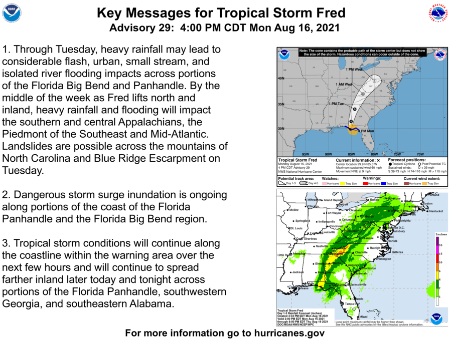
TS Fred Advisory # 29

BULLETIN
Tropical Storm Fred Advisory Number  29
NWS National Hurricane Center Miami FL       AL062021
400 PM CDT Mon Aug 16 2021

...FRED MOVING FARTHER INLAND OVER THE EASTERN FLORIDA PANHANDLE...
...HEAVY RAIN AND STORM SURGE THREAT CONTINUES...


SUMMARY OF 400 PM CDT...2100 UTC...INFORMATION
----------------------------------------------
LOCATION...29.9N 85.3W
ABOUT 25 MI...35 KM NW OF APALACHICOLA FLORIDA
MAXIMUM SUSTAINED WINDS...60 MPH...95 KM/H
PRESENT MOVEMENT...NNE OR 20 DEGREES AT 9 MPH...15 KM/H
MINIMUM CENTRAL PRESSURE...995 MB...29.39 INCHES


WATCHES AND WARNINGS
--------------------
CHANGES WITH THIS ADVISORY:

The Tropical Storm Warning west of the Okaloosa/Walton County line
is discontinued.

SUMMARY OF WATCHES AND WARNINGS IN EFFECT:

A Storm Surge Warning is in effect for...
* Coast of Florida from Indian Pass to Yankeetown

A Tropical Storm Warning is in effect for...
* Coast of the Florida Panhandle and Big Bend from the
Okaloosa/Walton County line to the Steinhatchee River

A Storm Surge Warning means there is a danger of life-threatening
inundation from rising water moving inland from the coastline in
the indicated locations. For a depiction of areas at risk, please
see the National Weather Service Storm Surge Watch/Warning Graphic,
available at hurricanes.gov.  This is a life-threatening situation.
Persons located within these areas should take all necessary
actions to protect life and property from rising water and the
potential for other dangerous conditions.  Promptly follow
evacuation and other instructions from local officials.

A Tropical Storm Warning means that tropical storm conditions are
expected somewhere within the warning area.

For storm information specific to your area, including possible
inland watches and warnings, please monitor products issued by your
local National Weather Service forecast office.


DISCUSSION AND OUTLOOK
----------------------
At 400 PM CDT (2100 UTC), the center of Tropical Storm Fred was
located near latitude 29.9 North, longitude 85.3 West.  Fred is
moving toward the north-northeast near 9 mph (15 km/h), and this
general motion with an increase in forward speed is expected over
the next couple of days.  On the forecast track, Fred will move from
western Georgia on Tuesday across the southern Appalachian 
Mountains to West Virginia by Wednesday.

Maximum sustained winds are near 60 mph (95 km/h) with higher gusts.
Rapid weakening is expected, and Fred should become a tropical
depression by early Tuesday.

Tropical-storm-force winds extend outward up to 115 miles (185 km)
from the center.  A sustained wind of 49 mph ( 79 km/h) with a gust
to 68 mph (109 km/h) was recently observed at the Apalachicola
Airport.

The estimated minimum central pressure is 995 mb (29.39 inches).


HAZARDS AFFECTING LAND
----------------------
Key messages for Fred can be found in the Tropical Cyclone
Discussion under AWIPS header MIATCDAT1, WMO header WTNT41 KNHC and
on the web at www.hurricanes.gov/graphics_at1.shtml?key_messages.

RAINFALL:

Fred is expected to produce the following rainfall amounts:

Through Tuesday...

The Florida Big Bend and Panhandle... 4 to 8 inches of rain with
isolated maximum storm totals of 12 inches are expected.

Southeast Alabama through western and northern Georgia, and the
western Carolinas... 4 to 8 inches of rain with isolated maximum
storm totals of 10 inches are expected.

Through Wednesday...

Portions of the Mid-Atlantic States...2 to 4 inches of rain with
isolated maximum storm totals of 6 inches expected as Fred interacts
with a nearby front.

Heavy rainfall across portions of the Southeast and Mid-Atlantic
States could lead to flash, urban, small stream and isolated river
flooding impacts.  An increased risk of landslides exists across the
mountains of North Carolina as well as portions of the Blue Ridge
Escarpment on Tuesday.

STORM SURGE:  The combination of a dangerous storm surge and the
tide will cause normally dry areas near the coast to be flooded by
rising waters moving inland from the shoreline.  The water could
reach the following heights above ground somewhere in the indicated
areas if the peak surge occurs at the time of high tide...

Indian Pass to Steinhatchee River...3-5 ft
Steinhatchee River to Yankeetown, FL...2-4 ft


Okaloosa/Walton County Line, FL to Indian Pass including
Choctawhatchee Bay and Saint Andrew Bay... 1-3 ft
Yankeetown, FL to Aripeka, FL...1-3 ft

The deepest water will occur along the immediate coast near and to
the east of the landfall location, where the surge will be
accompanied by large waves.  Surge-related flooding depends on the
relative timing of the surge and the tidal cycle, and can vary
greatly over short distances.  For information specific to your
area, please see products issued by your local National Weather
Service forecast office.

WIND:  Tropical storm conditions will continue in portions of the
Tropical Storm warning area for the next few hours.

SURF:  Swells generated by Fred are affecting the coasts of
Mississippi, Alabama and the Florida Panhandle, and could
causing life-threatening surf and rip current conditions.  Please
consult products from your local weather office for more details.

TORNADOES:  A few tornadoes are possible this evening and tonight
across parts of the Florida Panhandle, southwest Georgia, and
southeast Alabama.  The tornado threat will shift northward into
parts of northeast Georgia, the western Carolinas, and southern
Virginia on Tuesday.

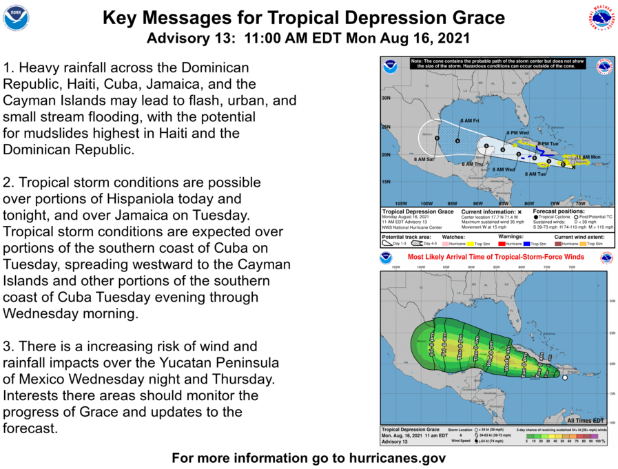
TD Grace Advisory # 13

BULLETIN
Tropical Depression Grace Advisory Number  13
NWS National Hurricane Center Miami FL       AL072021
1100 AM EDT Mon Aug 16 2021

...CENTER OF GRACE JUST ABOUT TO CROSS THE BARAHONA PENINSULA OF 
THE DOMINICAN REPUBLIC...
...FLASH FLOODING AND MUDSLIDES POSSIBLE ACROSS THE DOMINICAN
REPUBLIC AND HAITI TODAY...


SUMMARY OF 1100 AM EDT...1500 UTC...INFORMATION
-----------------------------------------------
LOCATION...17.7N 71.4W
ABOUT 85 MI...140 KM SE OF PORT AU PRINCE HAITI
ABOUT 430 MI...690 KM E OF MONTEGO BAY JAMAICA
MAXIMUM SUSTAINED WINDS...35 MPH...55 KM/H
PRESENT MOVEMENT...W OR 280 DEGREES AT 15 MPH...24 KM/H
MINIMUM CENTRAL PRESSURE...1007 MB...29.74 INCHES


WATCHES AND WARNINGS
--------------------
CHANGES WITH THIS ADVISORY:

The government of Cuba has issued a Tropical Storm Warning for the
southern coasts of the provinces of Santiago de Cuba, Granma, Las
Tunas, and Camaguey.  A Tropical Storm Watch has been issued for
the southern coasts of the provinces of Ciego de Avila, Sancti
Spiritus, Cienfuegos, and Matanzas, as well as Isla de la Juventud.

The government of the Cayman Islands has issued a Tropical Storm
Warning for the Cayman Islands.

SUMMARY OF WATCHES AND WARNINGS IN EFFECT:

A Tropical Storm Warning is in effect for...
* Southern coast of the Cuban provinces of Santiago de Cuba, Granma,
Las Tunas, and Camaguey
* Cayman Islands

A Tropical Storm Watch is in effect for...
* Entire coast of the Dominican Republic
* Entire coast of Haiti
* Jamaica
* Southern coast of the Cuban provinces of Ciego de Avila, Sancti
Spiritus, Cienfuegos, and Matanzas, as well as Isla de la Juventud.

A Tropical Storm Warning means that tropical storm conditions are
expected somewhere within the warning area within 36 hours.

A Tropical Storm Watch means that tropical storm conditions are
possible within the watch area, generally within 48 hours.

Interests elsewhere in Cuba and the Yucatan Peninsula of Mexico
should monitor the progress of Grace.  Additional watches or
warnings are possible later today or tonight.

For storm information specific to your area, please monitor
products issued by your national meteorological service.


DISCUSSION AND OUTLOOK
----------------------
At 1100 AM EDT (1500 UTC), the center of Tropical Depression Grace
was located near latitude 17.7 North, longitude 71.4 West.  Grace
is moving toward the west near 15 mph (24 km/h). A westward to 
west-northwestward motion is expected over the next several days.  
On the forecast track, the center of Grace will pass near the 
southern coast of Hispaniola today and tonight, and then pass 
between Jamaica, Cuba, and the Cayman Islands on Tuesday and 
Wednesday.

Maximum sustained winds are near 35 mph (55 km/h) with higher gusts.
Some strengthening is forecast during the next few days, and Grace
is expected to become a tropical storm again by Tuesday.

The estimated minimum central pressure is 1007 mb (29.74 inches).


HAZARDS AFFECTING LAND
----------------------
Key messages for Grace can be found in the Tropical Cyclone
Discussion under AWIPS header MIATCDAT2, WMO header WTNT42 KNHC
and on the web at 
www.hurricanes.gov/graphics_at2.shtml?key_messages.

WIND:  Tropical storm conditions are possible in the Dominican
Republic today, in Haiti today into tonight, and in Jamaica on
Tuesday.  Tropical storm conditions are expected along the southern
coast of Cuba within the warning area on Tuesday, and over the
Cayman Islands beginning late Tuesday into early Wednesday.
Tropical storm conditions are possible along the southern coast of
Cuba within the watch area Tuesday night and Wednesday.

RAINFALL:  Grace is expected to produce the following rainfall
amounts:

Over Haiti and the Dominican Republic...5 to 10 inches of rain with
isolated maximum totals of 15 inches are expected across the
southern terrain areas through Tuesday. This heavy rainfall may lead
to flash and urban flooding, and possible mudslides.

Over Cuba, Jamaica, and the Cayman Islands...2 to 4 inches of rain
with isolated maximum totals of 6 inches are expected through
Thursday.

SURF:  Swells generated by Grace will continue to affect portions of
Hispaniola and Puerto Rico over the next day or so, and will spread
westward to Jamaica, the Cayman Islands, and the southern coast
of Cuba.  These swells are likely to cause life-threatening surf
and rip current conditions. Please consult products from your local
weather office.

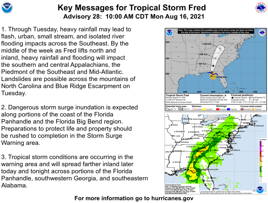
TS Fred Advisory # 28

Tropical Storm Fred Advisory Number  28
NWS National Hurricane Center Miami FL       AL062021
1000 AM CDT Mon Aug 16 2021

...FRED EXPECTED TO BRING A DANGEROUS STORM SURGE AND HEAVY RAINS 
TO THE FLORIDA PANHANDLE AND BIG BEND...
...TROPICAL STORM WARNING EXTENDED EASTWARD TO STEINHATCHEE RIVER...


SUMMARY OF 1000 AM CDT...1500 UTC...INFORMATION
-----------------------------------------------
LOCATION...29.2N 85.7W
ABOUT 55 MI...90 KM SW OF APALACHICOLA FLORIDA
MAXIMUM SUSTAINED WINDS...60 MPH...95 KM/H
PRESENT MOVEMENT...N OR 10 DEGREES AT 10 MPH...17 KM/H
MINIMUM CENTRAL PRESSURE...993 MB...29.32 INCHES


WATCHES AND WARNINGS
--------------------
CHANGES WITH THIS ADVISORY:

The Tropical Storm Warning for the Florida Big Bend area is
extended eastward to the Steinhatchee River.

SUMMARY OF WATCHES AND WARNINGS IN EFFECT:

A Storm Surge Warning is in effect for...
* Coast of Florida from Indian Pass to Yankeetown

A Tropical Storm Warning is in effect for...
* Coast of the Florida Panhandle and Big Bend from Navarre to the
Steinhatchee River

A Storm Surge Warning means there is a danger of life-threatening
inundation from rising water moving inland from the coastline in 
the indicated locations. For a depiction of areas at risk, please 
see the National Weather Service Storm Surge Watch/Warning Graphic, 
available at hurricanes.gov.  This is a life-threatening situation. 
Persons located within these areas should take all necessary 
actions to protect life and property from rising water and the 
potential for other dangerous conditions.  Promptly follow 
evacuation and other instructions from local officials.

A Tropical Storm Warning means that tropical storm conditions are
expected somewhere within the warning area, in this case within the
next 12 hours.

For storm information specific to your area, including possible
inland watches and warnings, please monitor products issued by your
local National Weather Service forecast office.


DISCUSSION AND OUTLOOK
----------------------
At 1000 AM CDT (1500 UTC), the center of Tropical Storm Fred was
located near latitude 29.2 North, longitude 85.7 West.  Fred is
moving toward the north near 10 mph (17 km/h), and this general
motion is expected through tonight.  On the forecast track, the
center of Fred should make landfall in the eastern Florida
Panhandle this afternoon or early this evening, and move over
western Georgia on Tuesday.

Maximum sustained winds are near 60 mph (95 km/h) with higher gusts. 
Some strengthening is possible before landfall. After landfall, 
Fred is expected to quickly weaken.

Tropical-storm-force winds extend outward up to 115 miles (185 km)
from the center. A National Ocean Service observation site at 
Apalachicola, Florida, recently reported a wind gust of 37 mph (59 
km/h). NOAA buoy 42039, located about 130 miles (215 km) 
south-southeast of Pensacola, Florida, recently reported a 
sustained wind of 56 mph (90 km/h). 

The estimated minimum central pressure based on data from an Air 
Force Reserve Hurricane Hunter Aircraft is 993 mb (29.32 inches).


HAZARDS AFFECTING LAND
----------------------
Key messages for Fred can be found in the Tropical Cyclone
Discussion under AWIPS header MIATCDAT1, WMO header WTNT41 KNHC and
on the web at www.hurricanes.gov/graphics_at1.shtml?key_messages.

RAINFALL:

Fred is expected to produce the following rainfall amounts:

Through Monday...

Southern and Central Florida... 1 to 2 inches of additional rain
with isolated maximum storm totals of 5 inches are expected.

Through Tuesday...

The Florida Big Bend and Panhandle... 4 to 8 inches of rain with
isolated maximum storm totals of 12 inches are expected.

Southeast Alabama through western and northern Georgia, and the
western Carolinas... 4 to 7 inches of rain with isolated maximum
storm totals of 10 inches are expected.

Through Wednesday...

Portions of the Mid-Atlantic States... 2 to 4 inches of rain with
isolated maximum storm totals of 6 inches expected as Fred interacts
with a nearby front.

Heavy rainfall across portions of the Southeast and Mid-Atlantic
States could lead to flash, urban, small stream and isolated river
flooding impacts.  An increased risk of landslides exists across the
mountains of North Carolina as well as portions of the Blue Ridge
Escarpment on Tuesday.

STORM SURGE:  The combination of a dangerous storm surge and the
tide will cause normally dry areas near the coast to be flooded by
rising waters moving inland from the shoreline.  The water could
reach the following heights above ground somewhere in the indicated
areas if the peak surge occurs at the time of high tide...

Indian Pass, FL to Steinhatchee River, FL...3-5 ft
Steinhatchee River, FL to Yankeetown, FL...2-4 ft
AL/FL border to Indian Pass including Pensacola Bay, Choctawhatchee
Bay and Saint Andrew Bay...1-3 ft
Yankeetown, FL to Aripeka, FL...1-3 ft

The deepest water will occur along the immediate coast near and to
the east of the landfall location, where the surge will be
accompanied by large waves.  Surge-related flooding depends on the
relative timing of the surge and the tidal cycle, and can vary
greatly over short distances.  For information specific to your
area, please see products issued by your local National Weather
Service forecast office.

WIND:  Tropical storm conditions have begun to occur in portions of
the Tropical Storm warning area.

SURF:  Swells generated by Fred are affecting the coasts of 
Mississippi, Alabama and the Florida Panhandle, and could
causing life-threatening surf and rip current conditions.  Please
consult products from your local weather office for more details.

TORNADOES:  A few tornadoes are possible today and tonight across
parts of the Florida Panhandle, southwest Georgia, and southeast
Alabama.

National Aviation Hall of Fame

“There’s no way you can visualize the speed. There’s nothing you can see to see how fast you’re going. You have no depth perception. If you’re in a car driving down the road and you close your eyes, you have no idea what your speed is. It’s the same thing if you’re free-falling from space. There are no signposts. You know you are going very fast, but you don’t feel it. You don’t have a 614-mph wind blowing on you. I could only hear myself breathing in the helmet.”

#OTD in 1960, Enshrinee Joe Kittinger took a leap beyond belief. As part of Project Excelsior, a series of experiments to investigate the effects of high altitude bailouts, Kittinger established that it was possible to put a human into space. 61 years ago, he piloted a gondola to an altitude of 102,800 feet before stepping into the unknown. Joe set two world records…one for the highest balloon ascent and another for the longest parachute freefall.

What did you do today?

#enshrinee #legend #legendary #usaf #parachute #parachutejump #bravery #space


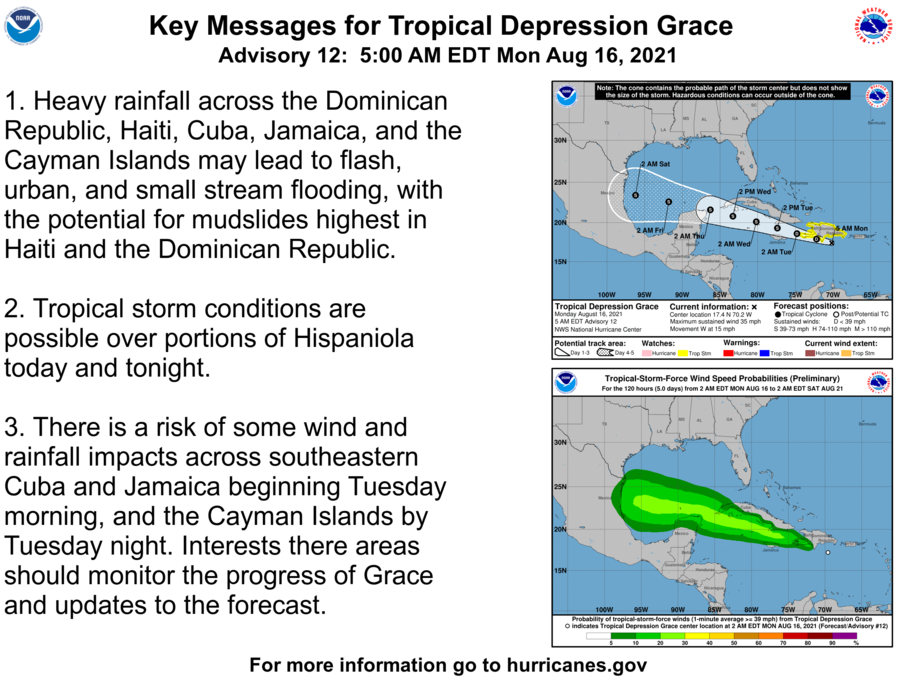
TD Grace Advisory # 12A

BULLETIN
Tropical Depression Grace Intermediate Advisory Number 12A
NWS National Hurricane Center Miami FL       AL072021
800 AM EDT Mon Aug 16 2021

...AIR FORCE RESERVE AND NOAA HURRICANE HUNTERS INVESTIGATING 
GRACE...
...FLASH FLOODING AND MUDSLIDES POSSIBLE ACROSS THE DOMINICAN 
REPUBLIC AND HAITI TODAY...


SUMMARY OF 800 AM EDT...1200 UTC...INFORMATION
----------------------------------------------
LOCATION...17.4N 70.9W
ABOUT 125 MI...200 KM SE OF PORT AU PRINCE HAITI
ABOUT 390 MI...625 KM E OF MONTEGO BAY JAMAICA
MAXIMUM SUSTAINED WINDS...35 MPH...55 KM/H
PRESENT MOVEMENT...W OR 275 DEGREES AT 15 MPH...24 KM/H
MINIMUM CENTRAL PRESSURE...1008 MB...29.77 INCHES


WATCHES AND WARNINGS
--------------------
CHANGES WITH THIS ADVISORY:

The government of Jamaica has issued a Tropical Storm Watch for 
Jamaica.

SUMMARY OF WATCHES AND WARNINGS IN EFFECT:

A Tropical Storm Watch is in effect for...
* Entire coast of the Dominican Republic
* Entire coast of Haiti
* Jamaica

A Tropical Storm Watch means that tropical storm conditions are
possible within the watch area, generally within 48 hours.

Interests elsewhere in Cuba and the Cayman Islands should monitor 
the progress of Grace.  Additional watches or warnings are likely 
later today or tonight.

For storm information specific to your area, please monitor
products issued by your national meteorological service.


DISCUSSION AND OUTLOOK
----------------------
At 800 AM EDT (1200 UTC), the center of Tropical Depression Grace
was located near latitude 17.4 North, longitude 70.9 West. The
depression is moving toward the west near 15 mph (24 km/h). A west
to west-northwestward motion is expected over the next several 
days.  On the forecast track, the center of Grace will pass near 
the southern coast of Hispaniola today and tonight, and then 
between Jamaica, Cuba, and the Cayman Islands on Tuesday and 
Wednesday.

Maximum sustained winds are near 35 mph (55 km/h) with higher
gusts. Little change in strength is forecast during the next day or
so. Slow strengthening is expected to begin by Tuesday.

Data from the NOAA Hurricane Hunter aircraft indicate that the 
minimum central pressure is 1008 mb (29.77 inches).


HAZARDS AFFECTING LAND
----------------------
Key messages for Grace can be found in the Tropical Cyclone
Discussion under AWIPS header MIATCDAT2 and WMO header WTNT42 KNHC
and on the web at
www.hurricanes.gov/graphics_at2.shtml?key_messages.

WIND:  Tropical storm conditions are possible in the Dominican
Republic today, in Haiti today into tonight, and in Jamaica on 
Tuesday.

RAINFALL:  Grace is expected to produce the following rainfall
amounts:

Over Haiti and the Dominican Republic...5 to 10 inches with 
isolated maximum totals of 15 inches are expected across the
southern terrain areas through Tuesday. This heavy rainfall may lead
to flash and urban flooding, and possible mudslides.

Over Cuba, Jamaica, and the Cayman Islands....2 to 4 inches with 
isolated maximum totals of 6 inches are expected through Thursday.

SURF:  Swells generated by Grace will continue to affect portions of
Hispaniola and Puerto Rico over the next day or so, and will spread
westward to Jamaica and the southern portions of Cuba. These swells
are likely to cause life-threatening surf and rip current
conditions. Please consult products from your local weather office.