BULLETIN
Tropical Storm Peter Advisory Number   9
NWS National Hurricane Center Miami FL       AL162021
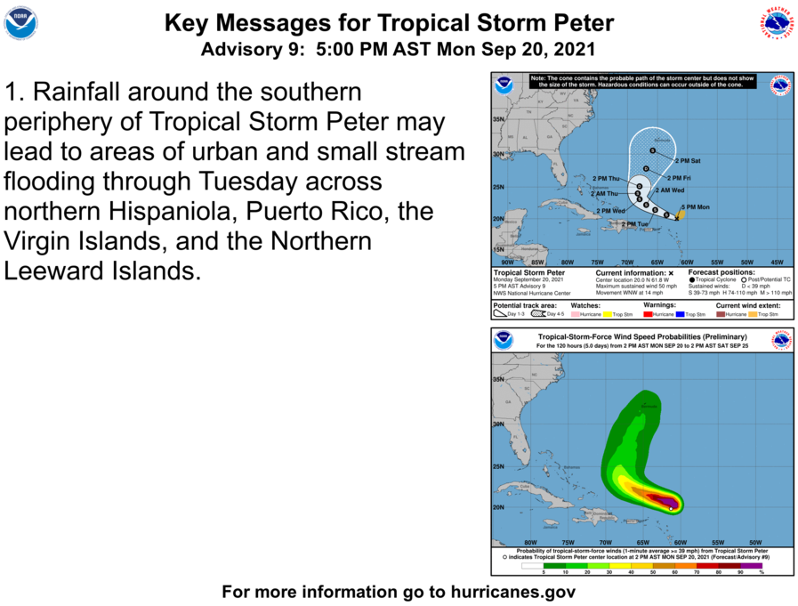
500 PM AST Mon Sep 20 2021

...PETER REFUSES TO SUCCUMB TO STRONG WIND SHEAR...
...STORM EXPECTED TO PASS NORTH OF THE LEEWARD ISLANDS EARLY THIS
WEEK...


SUMMARY OF 500 PM AST...2100 UTC...INFORMATION
----------------------------------------------
LOCATION...20.0N 61.8W
ABOUT 150 MI...240 KM NE OF THE NORTHERN LEEWARD ISLANDS
MAXIMUM SUSTAINED WINDS...50 MPH...85 KM/H
PRESENT MOVEMENT...WNW OR 290 DEGREES AT 14 MPH...22 KM/H
MINIMUM CENTRAL PRESSURE...1007 MB...29.74 INCHES


WATCHES AND WARNINGS
--------------------
There are no coastal watches or warnings in effect.

Interests in the northern Leeward Islands, Virgin Islands, and
Puerto Rico should monitor the progress of this system.


DISCUSSION AND OUTLOOK
----------------------
At 500 PM AST (2100 UTC), the center of Tropical Storm Peter was
located near latitude 20.0 North, longitude 61.8 West. Peter is
moving toward the west-northwest near 14 mph (22 km/h). This general
motion is expected to continue during the next day or so, followed
by a turn to the northwest with a decrease in forward speed on
Wednesday, and then a turn to the north by Wednesday night. On the
forecast track, the center of Peter will pass north of the northern
Leeward Islands and Puerto Rico through Tuesday.

Maximum sustained winds remain near 50 mph (85 km/h) with higher
gusts. Slow weakening is forecast during the next few days.

Tropical-storm-force winds extend outward up to 125 miles (205 km)
from the center.

The estimated minimum central pressure is 1007 mb (29.74 inches).


HAZARDS AFFECTING LAND
----------------------
RAINFALL:  Rainfall around the southern periphery of Tropical Storm
Peter could produce rainfall totals of 1 to 3 inches, with locally
higher amounts possible across portions of the Northern Leeward
Islands, including the Virgin Islands, as well as Puerto Rico and
the northern portions of Hispaniola through Tuesday. This rainfall
may lead to areas of urban and small stream flooding.

SURF:  Swells generated by Peter are expected to affect the northern
Leeward Islands early this week, and then reach the Bahamas by
midweek.  These swells could cause life-threatening surf and rip
current conditions. Please consult products from your local weather
office.
Category Archives: Weather
TS Rose Advisory # 5
BULLETIN
Tropical Storm Rose Advisory Number   5
NWS National Hurricane Center Miami FL       AL172021
500 AM AST Mon Sep 20 2021

...ROSE CONTINUES MOVING NORTHWESTWARD OVER THE EASTERN TROPICAL
ATLANTIC WITH NO CHANGE IN STRENGTH...


SUMMARY OF 500 AM AST...0900 UTC...INFORMATION
----------------------------------------------
LOCATION...15.9N 32.6W
ABOUT 550 MI...885 KM W OF THE SOUTHERNMOST CABO VERDE ISLANDS
MAXIMUM SUSTAINED WINDS...40 MPH...65 KM/H
PRESENT MOVEMENT...NW OR 315 DEGREES AT 15 MPH...24 KM/H
MINIMUM CENTRAL PRESSURE...1005 MB...29.68 INCHES


WATCHES AND WARNINGS
--------------------
There are no coastal watches or warnings in effect.


DISCUSSION AND OUTLOOK
----------------------
At 500 AM AST (0900 UTC), the center of Tropical Storm Rose was
located near latitude 15.9 North, longitude 32.6 West. Rose is
moving toward the northwest near 15 mph (24 km/h), and this motion
at a slightly slower forward speed is forecast over the next few
days.

Maximum sustained winds are near 40 mph (65 km/h) with higher gusts.
Slight strengthening will be possible today. By Tuesday, however,
upper-level winds are expected to become less conducive, and Rose is
forecast to begin a slow weakening trend.

Tropical-storm-force winds extend outward up to 35 miles (55 km)
from the center.

The estimated minimum central pressure is 1005 mb (29.68 inches).


HAZARDS AFFECTING LAND
----------------------
None.
TS Peter Advisory # 7
BULLETIN
Tropical Storm Peter Advisory Number   7
NWS National Hurricane Center Miami FL       AL162021
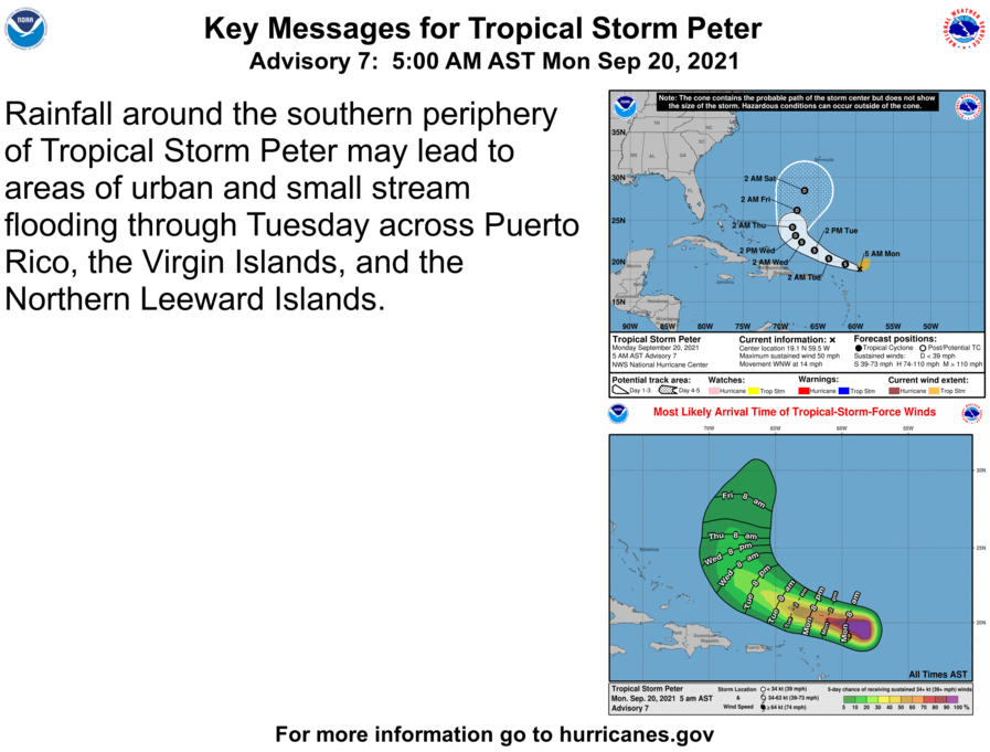
500 AM AST Mon Sep 20 2021

...RECONNAISSANCE AIRCRAFT FINDS PETER HAS CHANGED LITTLE...
...TROPICAL STORM EXPECTED TO PASS NORTH OF THE LEEWARD ISLANDS
EARLY THIS WEEK...


SUMMARY OF 500 AM AST...0900 UTC...INFORMATION
----------------------------------------------
LOCATION...19.1N 59.5W
ABOUT 245 MI...390 KM ENE OF THE NORTHERN LEEWARD ISLANDS
MAXIMUM SUSTAINED WINDS...50 MPH...85 KM/H
PRESENT MOVEMENT...WNW OR 290 DEGREES AT 14 MPH...22 KM/H
MINIMUM CENTRAL PRESSURE...1005 MB...29.68 INCHES


WATCHES AND WARNINGS
--------------------
There are no coastal watches or warnings in effect.

Interests in the northern Leeward Islands, Virgin Islands, and
Puerto Rico should monitor the progress of this system.


DISCUSSION AND OUTLOOK
----------------------
At 500 AM AST (0900 UTC), the center of Tropical Storm Peter was
located near latitude 19.1 North, longitude 59.5 West. Peter is
moving toward the west-northwest near 14 mph (22 km/h). This
general motion is expected to continue during the next couple of
days, followed by a turn to the northwest with a decrease in
forward speed on Wednesday.

Maximum sustained winds are near 50 mph (85 km/h) with higher gusts.
Slow weakening is forecast during the next several days.

Tropical-storm-force winds extend outward up to 125 miles (205 km),
primarily to the northeast of the center.

The estimated minimum central pressure is 1006 mb (29.71 inches).


HAZARDS AFFECTING LAND
----------------------
RAINFALL:  Rainfall around the southern periphery of Tropical Storm
Peter could produce rainfall totals of 1 to 3 inches, with locally
higher amounts possible, across portions of the Northern Leeward
Islands, including the Virgin Islands, as well as Puerto Rico
through Tuesday. This rainfall may lead to areas of urban and small
stream flooding.

SURF:  Swells generated by Peter are expected to affect the northern
Leeward Islands early this week, and then reach the Bahamas by
midweek.  These swells could cause life-threatening surf and rip
current conditions. Please consult products from your local weather
office.
TS Rose Advisory # 3
BULLETIN
Tropical Storm Rose Advisory Number   3
NWS National Hurricane Center Miami FL       AL172021
800 PM CVT Sun Sep 19 2021

...ROSE BECOMES THE SEVENTEENTH NAMED STORM OF THE BUSY 2021
HURRICANE SEASON...


SUMMARY OF 800 PM CVT...2100 UTC...INFORMATION
----------------------------------------------
LOCATION...14.3N 29.9W
ABOUT 370 MI...595 KM W OF THE SOUTHERNMOST CABO VERDE ISLANDS
MAXIMUM SUSTAINED WINDS...40 MPH...65 KM/H
PRESENT MOVEMENT...NNW OR 330 DEGREES AT 16 MPH...26 KM/H
MINIMUM CENTRAL PRESSURE...1005 MB...29.68 INCHES


WATCHES AND WARNINGS
--------------------
There are no coastal watches or warnings in effect.


DISCUSSION AND OUTLOOK
----------------------
At 800 PM CVT (2100 UTC), the center of Tropical Storm Rose was
located near latitude 14.3 North, longitude 29.9 West. Rose is
moving toward the north-northwest near 16 mph (26 km/h). A motion
toward the northwest is forecast to begin by tonight and continue
through Wednesday.

Maximum sustained winds have increased to near 40 mph (65 km/h)
with higher gusts.  Some strengthening is expected through Monday.
By Tuesday, environmental conditions are expected to become less
conducive, and Rose is forecast to begin a slow weakening trend.

Tropical-storm-force winds extend outward up to 35 miles (55 km)
from the center.

The estimated minimum central pressure is 1005 mb (29.68 inches).


HAZARDS AFFECTING LAND
----------------------
None.
TS Peter Advisory # 5
BULLETIN
Tropical Storm Peter Advisory Number   5
NWS National Hurricane Center Miami FL       AL162021
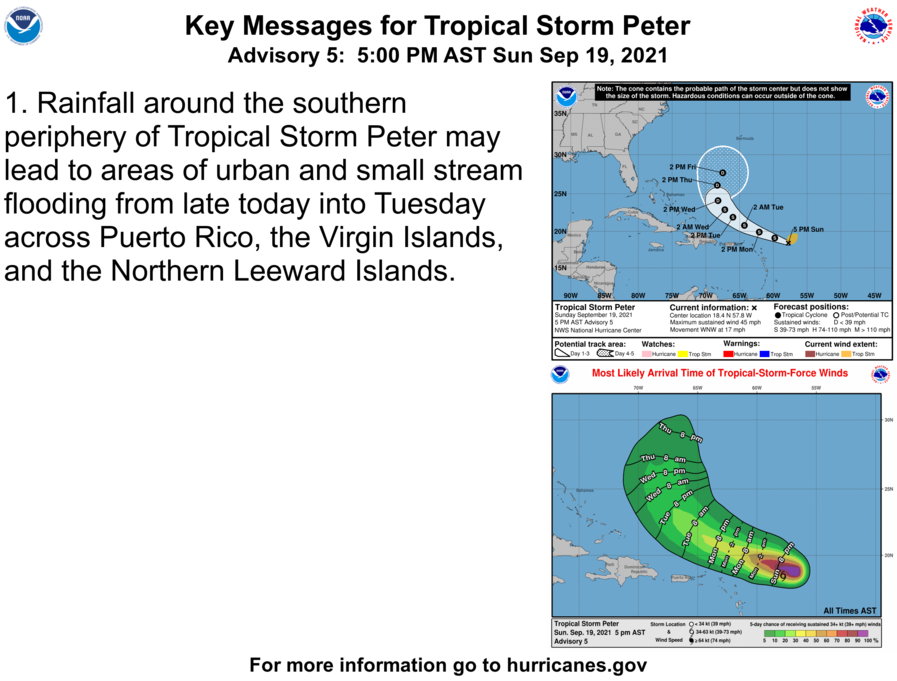
500 PM AST Sun Sep 19 2021

...PETER FENDING OFF STRONG WIND SHEAR...
...EXPECTED TO PASS NORTH OF THE LESSER ANTILLES EARLY THIS WEEK...


SUMMARY OF 500 PM AST...2100 UTC...INFORMATION
----------------------------------------------
LOCATION...18.4N 57.8W
ABOUT 350 MI...560 KM E OF THE NORTHERN LEEWARD ISLANDS
MAXIMUM SUSTAINED WINDS...45 MPH...75 KM/H
PRESENT MOVEMENT...WNW OR 290 DEGREES AT 17 MPH...28 KM/H
MINIMUM CENTRAL PRESSURE...1007 MB...29.74 INCHES


WATCHES AND WARNINGS
--------------------
There are no coastal watches or warnings in effect.

Interests in the northern Leeward Islands, Virgin Islands, and
Puerto Rico should monitor the progress of this system.


DISCUSSION AND OUTLOOK
----------------------
At 500 PM AST (2100 UTC), the center of Tropical Storm Peter was
located near latitude 18.4 North, longitude 57.8 West. Peter is
moving toward the west-northwest near 17 mph (28 km/h), and this
general motion along with a gradual decrease in forward speed is
is expected through Tuesday. A turn to the northwest is expected
to occur by Wednesday.  On the forecast track, the center of Peter
is expected to pass well north of the Leeward Islands on Monday and
Tuesday.

Maximum sustained winds are near 45 mph (75 km/h) with higher
gusts. Little change in strength is forecast tonight. Some slight
weakening is expected on Monday.

Tropical-storm-force winds extend outward up to 125 miles (205 km)
primarily to the northeast of the center.

The estimated minimum central pressure is 1007 mb (29.74 inches).


HAZARDS AFFECTING LAND
----------------------
RAINFALL:  Rainfall around the southern periphery of Tropical Storm
Peter could produce rainfall totals of 1 to 3 inches, with locally
higher amounts possible, across portions of the Northern Leeward
Islands, including the Virgin Islands, as well as Puerto Rico
through Tuesday. This rainfall may lead to areas of urban and small
stream flooding.

SURF:  Swells generated by Tropical Storm Peter are expected to
reach the northern Leeward Islands tonight and Monday, and then the
Bahamas by midweek.  These swells could cause life-threatening surf
and rip current conditions. Please consult products from your local
weather office.
T.D. 17, Advisory # 1
BULLETIN
Tropical Depression Seventeen Advisory Number   1
NWS National Hurricane Center Miami FL       AL172021
800 AM CVT Sun Sep 19 2021

...NEW TROPICAL DEPRESSION FORMS OVER THE FAR EASTERN TROPICAL
ATLANTIC...


SUMMARY OF 800 AM CVT...0900 UTC...INFORMATION
----------------------------------------------
LOCATION...11.8N 28.2W
ABOUT 330 MI...530 KM SW OF THE SOUTHERNMOST CABO VERDE ISLANDS
MAXIMUM SUSTAINED WINDS...35 MPH...55 KM/H
PRESENT MOVEMENT...NNW OR 330 DEGREES AT 14 MPH...22 KM/H
MINIMUM CENTRAL PRESSURE...1007 MB...29.74 INCHES


WATCHES AND WARNINGS
--------------------
There are no coastal watches or warnings in effect.


DISCUSSION AND OUTLOOK
----------------------
At 800 AM CVT (0900 UTC), the center of newly formed Tropical
Depression Seventeen was located near latitude 11.8 North, longitude
28.2 West. The depression is moving toward the north-northwest near
14 mph (22 km/h), and this general motion is expected to continue
today.  A motion toward northwest is forecast to begin by tonight
and continue through Tuesday.

Maximum sustained winds are near 35 mph (55 km/h) with higher gusts.
Some strengthening is expected for the next couple of days, and the
depression could become a tropical storm later today or on Monday.
By Tuesday, environmental conditions are is expected to become less
conducive for development, and the system is forecast to begin a
slow weakening trend.

The estimated minimum central pressure is 1007 mb (29.74 inches).


HAZARDS AFFECTING LAND
----------------------
None.
T.S. Peter Advisory # 3
BULLETIN
Tropical Storm Peter Special Advisory Number   3
NWS National Hurricane Center Miami FL       AL162021
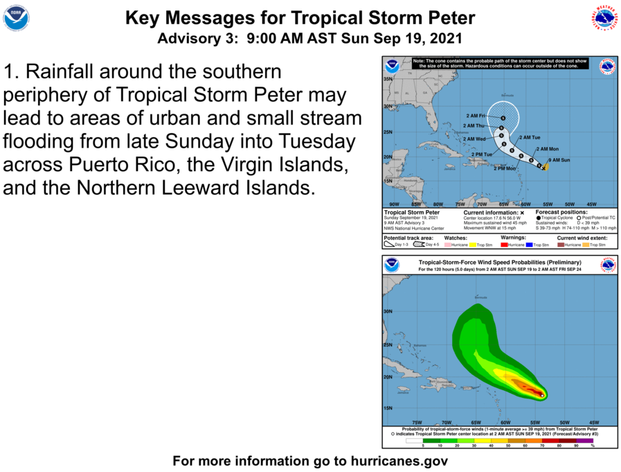
900 AM AST Sun Sep 19 2021

...CENTER OF PETER FOUND FARTHER SOUTH AND WEST...
...STILL EXPECTED TO PASS WELL NORTH OF THE LESSER ANTILLES...


SUMMARY OF 900 AM AST...1300 UTC...INFORMATION
----------------------------------------------
LOCATION...17.6N 56.0W
ABOUT 470 MI...755 KM E OF THE NORTHERN LEEWARD ISLANDS
MAXIMUM SUSTAINED WINDS...45 MPH...75 KM/H
PRESENT MOVEMENT...WNW OR 290 DEGREES AT 15 MPH...24 KM/H
MINIMUM CENTRAL PRESSURE...1008 MB...29.77 INCHES


WATCHES AND WARNINGS
--------------------
There are no coastal watches or warnings in effect.

Interests in the northern Leeward Islands, Virgin Islands, and
Puerto Rico should monitor the progress of this system.


DISCUSSION AND OUTLOOK
----------------------
At 900 AM AST (1300 UTC), the center of Tropical Storm Peter was
located near latitude 17.6 North, longitude 56.0 West. Peter is
moving toward the west-northwest near 15 mph (24 km/h) and this
motion is expected to continue through Wednesday. On the forecast
track, Peter is expected to pass well to the north of the northern
Leeward Islands on Monday and Tuesday.

Maximum sustained winds are near 45 mph (75 km/h) with higher gusts.
Some additional strengthening is forecast during the next day or
so, followed by a slow weakening trend by late Monday and on
Tuesday.

Tropical-storm-force winds extend outward up to 105 miles (170 km)
from the center.

The estimated minimum central pressure is 1008 mb (29.77 inches).


HAZARDS AFFECTING LAND
----------------------
RAINFALL:  The outer bands south of the Tropical Storm Peter could
produce rainfall totals of 1 to 3 inches across portions of the
Northern Leeward Islands, including the Virgin Islands, as well as
Puerto Rico late Sunday into Tuesday. This rainfall may lead to
areas of urban and small stream flooding.

SURF:  Swells generated by Tropical Storm Peter are expected to
reach the northern Leeward Islands Sunday night and Monday.  These
swells could cause life-threatening surf and rip current conditions.
Please consult products from your local weather office.
Tropical Update 9/18 1400 EDT
Tropical Weather Outlook
NWS National Hurricane Center Miami FL
200 PM EDT Sat Sep 18 2021

For the North Atlantic...Caribbean Sea and the Gulf of Mexico:

The National Hurricane Center is issuing advisories on Tropical
Storm Odette, located a few hundred miles southeast of
Nantucket, Massachusetts.

1. Showers and thunderstorms associated with an area of low pressure
located about 650 miles east-southeast of the northern Leeward
Islands continue to show signs of organization.  However,
satellite-derived wind data from a few hours ago indicated that the
system does not yet have a well-defined surface circulation.  Only
a slight increase in organization of this system would lead to the
formation of a tropical depression or tropical storm, which is
expected to occur later today or tonight while the low moves toward
the west-northwest at about 15 mph.  This system is expected to be
near the northern Leeward Islands on Monday and Tuesday, and
interests there should monitor its progress.  Upper-level winds are
likely to become less conducive for development when the system
reaches the southwestern Atlantic by the early to middle part of
next week.  Additional information on this system, including gale
warnings, can be found in High Seas Forecasts issued by the National
Weather Service.
* Formation chance through 48 hours...high...90 percent.
* Formation chance through 5 days...high...90 percent.

2. A low pressure system located over the far eastern Atlantic a few
hundred miles south-southwest of the Cabo Verde Islands continues
to show some signs of organization.  Environmental conditions
appear conducive for further development of this system, and a
tropical depression could form over the next couple of days while
moving toward the northwest at 10 to 15 mph to the west of the Cabo
Verde Islands.  This system is expected to reach cooler waters and
an area of stronger upper-level winds early next week, which could
limit its development.
* Formation chance through 48 hours...medium...50 percent.
* Formation chance through 5 days...medium...50 percent.

Public Advisories on Tropical Storm Odette are issued under
WMO header WTNT35 KNHC and under AWIPS header MIATCPAT5.
Forecast/Advisories on Tropical Storm Odette are issued under
WMO header WTNT25 KNHC and under AWIPS header MIATCMAT5.

High Seas Forecasts issued by the National Weather Service
can be found under AWIPS header NFDHSFAT1, WMO header FZNT01
KWBC, and online at ocean.weather.gov/shtml/NFDHSFAT1.php
Tropical Outlook 9/18
Tropical Weather Outlook
NWS National Hurricane Center Miami FL
800 AM EDT Sat Sep 18 2021

For the North Atlantic...Caribbean Sea and the Gulf of Mexico:

The National Hurricane Center is issuing advisories on Tropical
Storm Odette, located a couple of hundred miles south-southeast of
Nantucket, Massachusetts.

1. Showers and thunderstorms continue to become better organized in
association with an area of low pressure located about 650 miles
miles east-southeast of the northern Leeward Islands.
Environmental conditions are expected to be conducive for further
development during the next day or two, and a tropical depression
or tropical storm is expected to form later today or tonight while
the system moves toward the west-northwest at about 15 mph.  This
system is expected to be near the northern Leeward Islands on
Monday and Tuesday, and interests there should monitor its progress.
Upper-level winds are likely to become less conducive for
development when the system reaches the southwestern Atlantic by the
early to middle part of next week.  Additional information on this
system, including gale warnings, can be found in High Seas Forecasts
issued by the National Weather Service.
* Formation chance through 48 hours...high...90 percent.
* Formation chance through 5 days...high...90 percent.

2. A broad area of low pressure is located over the far eastern
Atlantic a few hundred miles south of the Cabo Verde Islands.  The
associated shower and thunderstorm activity has become a little
better organized since yesterday, and environmental conditions
appear conducive for further development during the next couple of
days.  A tropical depression could form while the system moves
northwestward at about 10 mph to the west of the Cabo Verde
Islands before it reaches cooler waters and stronger upper-level
winds early next week.
* Formation chance through 48 hours...medium...40 percent.
* Formation chance through 5 days...medium...40 percent.

Public Advisories on Tropical Storm Odette are issued under
WMO header WTNT35 KNHC and under AWIPS header MIATCPAT5.
Forecast/Advisories on Tropical Storm Odette are issued under
WMO header WTNT25 KNHC and under AWIPS header MIATCMAT5.

High Seas Forecasts issued by the National Weather Service
can be found under AWIPS header NFDHSFAT1, WMO header FZNT01
KWBC, and online at ocean.weather.gov/shtml/NFDHSFAT1.php
T.S. Odette Advisory #1
BULLETIN
Tropical Storm Odette Advisory Number   1
NWS National Hurricane Center Miami FL       AL152021
500 PM EDT Fri Sep 17 2021

...TROPICAL STORM ODETTE FORMS OFF THE U.S. MID-ATLANTIC COAST...
...FORECAST TO BECOME POST-TROPICAL BY SATURDAY NIGHT SOUTH OF
ATLANTIC CANADA...


SUMMARY OF 500 PM EDT...2100 UTC...INFORMATION
----------------------------------------------
LOCATION...36.7N 71.8W
ABOUT 225 MI...365 KM SE OF CAPE MAY NEW JERSEY
ABOUT 325 MI...525 KM SSW OF NANTUCKET MASSACHUSETTS
MAXIMUM SUSTAINED WINDS...40 MPH...65 KM/H
PRESENT MOVEMENT...NE OR 45 DEGREES AT 15 MPH...24 KM/H
MINIMUM CENTRAL PRESSURE...1010 MB...29.83 INCHES


WATCHES AND WARNINGS
--------------------
There are no coastal watches or warnings in effect.

Please refer to products issued by Environment Canada for Odette's
potential impacts to Newfoundland as a post-tropical cyclone.


DISCUSSION AND OUTLOOK
----------------------
At 500 PM EDT (2100 UTC), the center of Tropical Storm Odette was
located near latitude 36.7 North, longitude 71.8 West.  Odette is
moving toward the northeast near 15 mph (24 km/h), and this
general motion is expected to continue into tonight.  A turn toward
the east-northeast with an increase in forward speed is expected to
begin on Saturday and continue through Monday.  On the forecast
track, the center of Odette will move away from the U.S.
Mid-Atlantic coast and pass south of Atlantic Canada over the
weekend.

Maximum sustained winds are near 40 mph (65 km/h) with higher gusts.
Strengthening is forecast during the next couple of days, and
Odette is expected to become a strong post-tropical low by Saturday
night.

Tropical-storm-force winds extend outward up to 115 miles (185 km)
to the north of the center.

The estimated minimum central pressure is 1010 mb (29.83 inches).


HAZARDS AFFECTING LAND
----------------------
SURF:  Swells generated by Odette are affecting portions of
the United States Mid-Atlantic coast and are expected to spread
northward to portions of the U.S. Northeast and Atlantic Canada
coasts during the weekend.  These swells are likely to cause
life-threatening surf and rip current conditions.  Please consult
products from your local weather office.


