All posts by W4GVL

Welcome Shane!

LEXINGTON, Ky.Jeremy Foley and Lee McGriff have had a running back-and-forth for years. McGriff played wide receiver at Florida in the early 1970s, became a Gators assistant coach in the late-’70s and eventually was placed in the Gators Sports Network radio both as color analyst not once, but twice and has been there since 2004.

Foley, who retired as UF athletic director in 2017, still teases McGriff when he sees him on chartered flights to road games. 

“How long are you going to be on scholarship?” 

They always share a laugh about it. 

“I’m so grateful for it all,” McGriff this week. “And, yes, it feels like I’ve been on scholarship for about 50 years now.” 

McGriff, though, is about to give up his free ride, but for one he anticipates will every bit as rewarding. Probably more. 
 

Keil McGriff (left) with his grandfather


When Gator fans tune into Saturday night’s radio coverage of the Florida-Kentucky game from Lexington they’ll hear the familiar voice of Mick Hubert calling play-by-play, but a different voice — Shane Matthews, the former UF quarterback and two-time Southeastern Conference Player of the Year — providing the color commentary. McGriff, who turns 68 Sunday, is taking road games off this season as part of a roll back that will allow him to attend his grandson’s football games in 2022. 

If the scenario sounds familiar it’s because, well, it is. In 1994, McGriff asked out of his UF radio duties so he could watch — and cheer — for oldest son Travis during his time as a wideout for the Gators from ’95-98. McGriff’s hiatus continued when middle son Britt, also a wideout, signed to play with UCF. 

He did it then to play Dad. 

Now he’ll do it to play Granddad. 

“Easy decision,” said McGriff, whose grandson, Keil, is currently being coached at the middle-school level by Travis. “When you experience it with your own child, it’s their time and it’s such a big deal with how invested they are. But when it’s your grandchild, now you’re watching your child be who you were. I wasn’t going to miss any of that.” 

So McGriff approached the University Athletic Association with a heads-up. Where it all leads down the line is yet to be determined, but for the time being it will be Matthews, who left UF in 1992 as the SEC’s all-time leader in passing yards and touchdowns, in the seat next to Hubert, now in his 33rd season. 

Matthews played 13 seasons in the NFL for six different franchises, mostly as a backup. Now 51, Matthews has a daily podcast on Facebook and has done some color commentary for college games on Touchdown Radio. 

“Those are some big shoes to fill,” Matthews said of McGriff. “Hopefully, I can stay out of Mick’s way and bring something to the broadcast.” 

Former UF quarterback and two-time SEC Player of the Year Shane Matthews will provide color analysis on UF road games the rest of the 2021 season.

McGriff, who will be back in the booth for UF home games this season, has offered Matthews some tips, along with some well-wishes, as he prepares for what’s next. 

It’s not exactly walk-on status, but it’s not a full ride, either. 

“I’m on partial scholarship now,” McGriff smiled. “I get books and a few meals.” 

And glorious grandson time to make up for the rest. 
TS Victor Advisory # 8

BULLETIN
Tropical Storm Victor Advisory Number   8
NWS National Hurricane Center Miami FL       AL202021
500 AM AST Fri Oct 01 2021

...VICTOR MOVING NORTHWESTWARD OVER THE EASTERN TROPICAL ATLANTIC...


SUMMARY OF 500 AM AST...0900 UTC...INFORMATION
----------------------------------------------
LOCATION...11.7N 32.3W
ABOUT 630 MI...1015 KM WSW OF THE CABO VERDE ISLANDS
MAXIMUM SUSTAINED WINDS...60 MPH...95 KM/H
PRESENT MOVEMENT...NW OR 305 DEGREES AT 15 MPH...24 KM/H
MINIMUM CENTRAL PRESSURE...997 MB...29.44 INCHES


WATCHES AND WARNINGS
--------------------
There are no coastal watches or warnings in effect.


DISCUSSION AND OUTLOOK
----------------------
At 500 AM AST (0900 UTC), the center of Tropical Storm Victor was
located near latitude 11.7 North, longitude 32.3 West. Victor is
moving toward the northwest near 15 mph (24 km/h). A motion toward 
the west-northwest and northwest is expected today, followed by a
northwestward motion over the eastern tropical Atlantic over the 
weekend.

Maximum sustained winds are near 60 mph (95 km/h) with higher gusts.
Some slight strengthening will be possible through tonight, 
followed by a slow weakening trend over the weekend.

Tropical-storm-force winds extend outward up to 160 miles (260 km)
from the center.

The estimated minimum central pressure is 997 mb (29.44 inches).


HAZARDS AFFECTING LAND
----------------------
None.

Sam Advisory # 35A

BULLETIN
Hurricane Sam Intermediate Advisory Number 35A
NWS National Hurricane Center Miami FL       AL182021
800 AM AST Fri Oct 01 2021

...SAM REMAINS A POWERFUL CATEGORY 4 HURRICANE OVER THE CENTRAL 
ATLANTIC...
...TROPICAL STORM CONDITIONS EXPECTED ON BERMUDA BY TONIGHT OR
EARLY SATURDAY...


SUMMARY OF 800 AM AST...1200 UTC...INFORMATION
----------------------------------------------
LOCATION...27.5N 61.8W
ABOUT 380 MI...610 KM SSE OF BERMUDA
MAXIMUM SUSTAINED WINDS...150 MPH...240 KM/H
PRESENT MOVEMENT...NNW OR 345 DEGREES AT 17 MPH...28 KM/H
MINIMUM CENTRAL PRESSURE...934 MB...27.58 INCHES


WATCHES AND WARNINGS
--------------------
CHANGES WITH THIS ADVISORY:

None.

SUMMARY OF WATCHES AND WARNINGS IN EFFECT:

A Tropical Storm Warning is in effect for...
* Bermuda

A Tropical Storm Warning means that tropical storm conditions are
expected somewhere within the warning area within 36 hours.

For storm information specific to your area, please monitor
products issued by your national meteorological service.


DISCUSSION AND OUTLOOK
----------------------
At 800 AM AST (1200 UTC), the eye of Hurricane Sam was located near
latitude 27.5 North, longitude 61.8 West.  Sam is moving toward the
north-northwest near 17 mph (28 km/h).  A turn toward the north and
north-northeast, at a similar forward speed, is expected later today
and tonight, followed by a northeastward motion Saturday night
through Monday.  On the forecast track, the center of Sam will pass
well to the east of Bermuda tonight.

Maximum sustained winds are near 150 mph (240 km/h) with higher
gusts.  Sam is a category 4 hurricane on the Saffir-Simpson
Hurricane Wind Scale.  Although fluctuations in intensity are still
possible today, weakening is forecast during the next couple of
days.  However, Sam is expected to remain a major hurricane through
at least Saturday night.

Hurricane-force winds extend outward up to 70 miles (110 km) from
the center and tropical-storm-force winds extend outward up to 175
miles (280 km).

The estimated minimum central pressure is 934 mb (27.58 inches).


HAZARDS AFFECTING LAND
----------------------
Key messages for Sam can be found in the Tropical Cyclone Discussion
under AWIPS header MIATCDAT3 and WMO header WTNT43 KNHC, and on the
web at hurricanes.gov/graphics_at3.shtml?key_messages.

WIND:  Tropical storm conditions are expected on Bermuda beginning
tonight or early Saturday.

SURF:  Swells generated by Sam will impact the northern Leeward
Islands and the Greater Antilles, including Puerto Rico, during the
next couple of days.  Swells are expected to reach Bermuda and the
Bahamas later today, and then spread to the United States east
coast and Atlantic Canada this weekend.  These swells could cause
life-threatening surf and rip current conditions.  Please consult
products from your local weather office.

TS Victor Advisory # 7

BULLETIN
Tropical Storm Victor Advisory Number   7
NWS National Hurricane Center Miami FL       AL202021
1100 PM AST Thu Sep 30 2021

...VICTOR STRENGTHENS OVER THE TROPICAL EASTERN ATLANTIC...


SUMMARY OF 1100 PM AST...0300 UTC...INFORMATION
-----------------------------------------------
LOCATION...10.6N 30.7W
ABOUT 585 MI...940 KM SW OF THE CABO VERDE ISLANDS
MAXIMUM SUSTAINED WINDS...60 MPH...95 KM/H
PRESENT MOVEMENT...WNW OR 300 DEGREES AT 12 MPH...19 KM/H
MINIMUM CENTRAL PRESSURE...997 MB...29.44 INCHES


WATCHES AND WARNINGS
--------------------
There are no coastal watches or warnings in effect.


DISCUSSION AND OUTLOOK
----------------------
At 1100 PM AST (0300 UTC), the center of Tropical Storm Victor was
located near latitude 10.6 North, longitude 30.7 West. Victor is
moving toward the west-northwest near 12 mph (19 km/h).  A
west-northwest to northwest motion over the eastern tropical
Atlantic is expected through the weekend.

Recent satellite wind data indicate that maximum sustained winds 
are now near 60 mph (95 km/h) with higher gusts.  Gradual 
strengthening is forecast during the next day or so.  However, a 
weakening trend is expected to begin over the weekend.

Tropical-storm-force winds extend outward up to 175 miles (280 km)
mainly to the northeast of the center.

The estimated minimum central pressure is 997 mb (29.44 inches).


HAZARDS AFFECTING LAND
----------------------
None

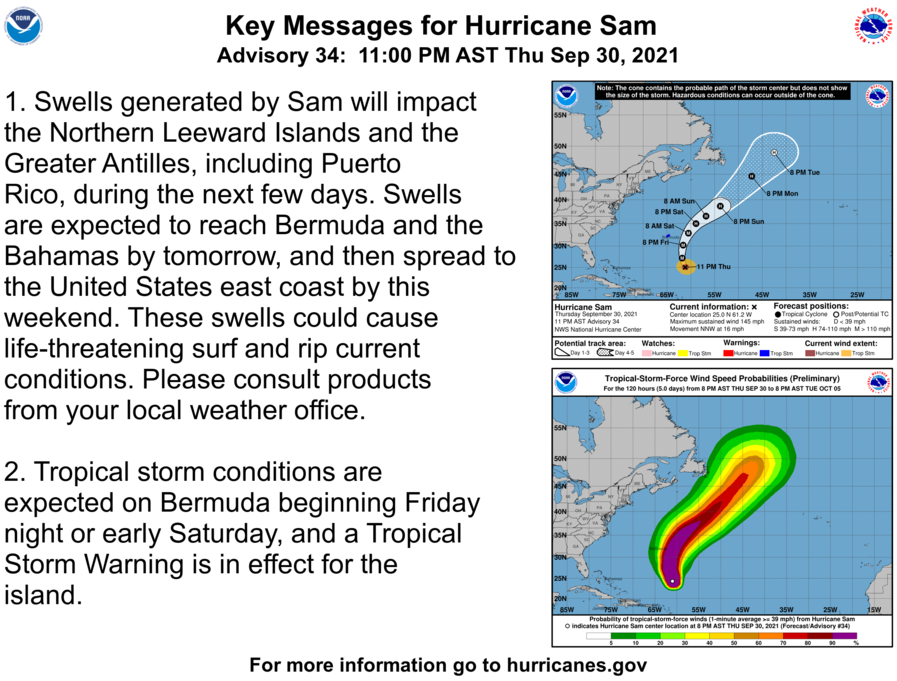
Sam Advisory # 34

BULLETIN
Hurricane Sam Advisory Number  34
NWS National Hurricane Center Miami FL       AL182021
1100 PM AST Thu Sep 30 2021

...SAM STILL A POWERFUL 145 MPH HURRICANE...
...DANGEROUS SURF EXPECTED FOR A LARGE PORTION OF THE WESTERN
ATLANTIC SHORELINE...


SUMMARY OF 1100 PM AST...0300 UTC...INFORMATION
-----------------------------------------------
LOCATION...25.0N 61.2W
ABOUT 550 MI...885 KM SSE OF BERMUDA
MAXIMUM SUSTAINED WINDS...145 MPH...230 KM/H
PRESENT MOVEMENT...NNW OR 345 DEGREES AT 16 MPH...26 KM/H
MINIMUM CENTRAL PRESSURE...938 MB...27.70 INCHES


WATCHES AND WARNINGS
--------------------
CHANGES WITH THIS ADVISORY:

None.

SUMMARY OF WATCHES AND WARNINGS IN EFFECT:

A Tropical Storm Warning is in effect for...
* Bermuda

A Tropical Storm Warning means that tropical storm conditions are
expected somewhere within the warning area within 36 hours.

For storm information specific to your area, please monitor
products issued by your national meteorological service.


DISCUSSION AND OUTLOOK
----------------------
At 1100 PM AST (0300 UTC), the center of Hurricane Sam was located 
near latitude 25.0 North, longitude 61.2 West. Sam is moving toward 
the north-northwest near 16 mph (26 km/h) and this motion with an 
slight increase in forward speed is expected tonight. A turn toward 
the north is anticipated on Friday, and a northeastward motion is 
forecast to begin on Saturday. On the forecast track, the core of 
Sam will pass to the east of Bermuda early Saturday.

Maximum sustained winds remain near 145 mph (230 km/h) with higher 
gusts.  Sam is a category 4 hurricane on the Saffir-Simpson 
Hurricane Wind Scale. Some fluctuations in intensity are expected 
during the next day or so, followed by gradual weakening. Sam is 
forecast to remain a major hurricane into Saturday, with additional
weakening forecast later in the weekend.

Hurricane-force winds extend outward up to 60 miles (95 km) from the
center and tropical-storm-force winds extend outward up to 150 miles
(240 km).

The estimated minimum central pressure is 938 mb (27.70 inches).


HAZARDS AFFECTING LAND
----------------------
Key messages for Sam can be found in the Tropical Cyclone
Discussion under AWIPS header MIATCDAT3 and WMO header WTNT43 KNHC,
and on the web at hurricanes.gov/graphics_at3.shtml?key_messages.

WIND:  Tropical storm conditions are expected on Bermuda beginning
Friday night or early Saturday.

SURF:  Swells generated by Sam will impact the northern Leeward
Islands and the Greater Antilles, including Puerto Rico, during the
next few days.  Swells are expected to reach Bermuda and the Bahamas
tomorrow, and then spread to the United States east coast by this
weekend.  These swells could cause life-threatening surf and rip
current conditions.  Please consult products from your local
weather office.

TS Victor Advisory # 6

BULLETIN
Tropical Storm Victor Advisory Number   6
NWS National Hurricane Center Miami FL       AL202021
500 PM AST Thu Sep 30 2021

...VICTOR HOLDING STEADY IN STRENGTH OVER THE TROPICAL EAST
ATLANTIC...


SUMMARY OF 500 PM AST...2100 UTC...INFORMATION
----------------------------------------------
LOCATION...9.9N 30.0W
ABOUT 585 MI...940 KM SW OF THE CABO VERDE ISLANDS
MAXIMUM SUSTAINED WINDS...45 MPH...75 KM/H
PRESENT MOVEMENT...WNW OR 290 DEGREES AT 14 MPH...22 KM/H
MINIMUM CENTRAL PRESSURE...1003 MB...29.62 INCHES


WATCHES AND WARNINGS
--------------------
There are no coastal watches or warnings in effect.


DISCUSSION AND OUTLOOK
----------------------
At 500 PM AST (2100 UTC), the center of Tropical Storm Victor was
located near latitude 9.9 North, longitude 30.0 West. Victor is
moving toward the west-northwest near 14 mph (22 km/h).  A
west-northwest to northwest motion over the eastern tropical
Atlantic is expected through the weekend.

Maximum sustained winds remain near 45 mph (75 km/h) with higher 
gusts. Gradual strengthening is forecast during the next day or so. 
However, a weakening trend is expected to begin over the weekend.

Tropical-storm-force winds extend outward up to 105 miles (165 km)
from the center.

The estimated minimum central pressure is 1003 mb (29.62 inches).


HAZARDS AFFECTING LAND
----------------------
None

Sam Advisory # 33A

BULLETIN
Hurricane Sam Intermediate Advisory Number 33A
NWS National Hurricane Center Miami FL       AL182021
800 PM AST Thu Sep 30 2021

...POWERFUL HURRICANE SAM NOW MOVING NORTH-NORTHWEST...
...DANGEROUS SURF EXPECTED FOR A LARGE PORTION OF THE WESTERN 
ATLANTIC SHORELINE...


SUMMARY OF 800 PM AST...0000 UTC...INFORMATION
----------------------------------------------
LOCATION...24.3N 61.0W
ABOUT 600 MI...965 KM SSE OF BERMUDA
MAXIMUM SUSTAINED WINDS...145 MPH...230 KM/H
PRESENT MOVEMENT...NNW OR 340 DEGREES AT 14 MPH...22 KM/H
MINIMUM CENTRAL PRESSURE...938 MB...27.70 INCHES


WATCHES AND WARNINGS
--------------------
CHANGES WITH THIS ADVISORY:

None.

SUMMARY OF WATCHES AND WARNINGS IN EFFECT:

A Tropical Storm Warning is in effect for...
* Bermuda

A Tropical Storm Warning means that tropical storm conditions are
expected somewhere within the warning area within 36 hours.

For storm information specific to your area, please monitor
products issued by your national meteorological service.


DISCUSSION AND OUTLOOK
----------------------
At 800 PM AST (0000 UTC), the eye of Hurricane Sam was located near 
latitude 24.3 North, longitude 61.0 West.  Sam is moving toward the 
north-northwest near 14 mph (22 km/h), and this continued motion 
with an additional increase in forward speed is expected tonight.  A 
turn toward the north is anticipated on Friday, and a northeastward 
motion is forecast to begin on Saturday. On the forecast track, the 
core of Sam will pass to the east of Bermuda early Saturday.

Maximum sustained winds remain near 145 mph (230 km/h) with higher 
gusts.  Sam is a category 4 hurricane on the Saffir-Simpson 
Hurricane Wind Scale.  Some fluctuations in intensity are expected 
during the next couple of days, but Sam is forecast to remain a 
major hurricane into Saturday, with more significant weakening 
anticipated later in the weekend.

Hurricane-force winds extend outward up to 60 miles (95 km) from
the center and tropical-storm-force winds extend outward up to 150
miles (240 km).

The estimated minimum central pressure is 938 mb (27.70 inches).


HAZARDS AFFECTING LAND
----------------------
Key messages for Sam can be found in the Tropical Cyclone
Discussion under AWIPS header MIATCDAT3 and WMO header WTNT43 KNHC,
and on the web at hurricanes.gov/graphics_at3.shtml?key_messages.

WIND:  Tropical storm conditions are expected on Bermuda beginning
Friday night or early Saturday.

SURF:  Swells generated by Sam will impact the northern Leeward
Islands and the Greater Antilles, including Puerto Rico, during the
next few days.  Swells are expected to reach Bermuda and the Bahamas
by Friday, and then spread to the United States east coast by this
weekend.  These swells could cause life-threatening surf and rip
current conditions.  Please consult products from your local
weather office.

Gator – Wildcat Game Info

The No. 10 Florida Gators (3-1, 0-0 SEC) take on a familiar opponent when they visit the Kentucky Wildcats (4-0, 0-0 SEC) on Saturday, October 2, 2021 at Kroger Field in a SEC showdown. Below is an article containing all the details you need, including how to watch this matchup on FuboTV.

How to Watch Kentucky vs. Florida

Florida and Kentucky Stats

  • The Gators put up 18.2 more points per game (36.0) than the Wildcats surrender (17.8).
  • The Gators have turned the ball over six times this season, four more turnovers than the Wildcats have forced (2).
  • The Wildcats have scored 31.0 points per game this year, 11.2 more than the Gators have given up.
  • The Wildcats have turned the ball over eight more times (11 total) than the Gators have forced a turnover (3) this season.

Florida Players to Watch

  • Emory Jones has thrown for 654 yards (163.5 ypg) to lead Florida, completing 67% of his passes and recording four touchdown passes and five interceptions this season. He’s also run for 379 yards (94.8 ypg) on 57 carries with two rushing touchdowns.
  • This season Anthony Richardson has racked up 11 carries for 275 yards (68.8 per game) and two touchdowns.
  • Jacob Copeland’s team-leading 232 receiving yards (58.0 yards per game) have come on 10 receptions with two touchdowns.
  • Xzavier Henderson has put up a 122-yard season so far (30.5 receiving yards per game) with one touchdown, hauling in eight passes.
  • Rick Wells’ 11 catches are good enough for 121 yards (30.3 ypg) and two touchdowns.

Kentucky Players to Watch

  • Will Levis leads Kentucky with 902 passing yards (225.5 ypg) on 66-of-101 passing with seven touchdowns compared to five interceptions this season. He also adds 67 rushing yards (16.8 ypg) on 23 carries while scoring one touchdown on the ground.
  • Christopher Rodriguez Jr.’s team-high 521 rushing yards (130.3 per game) have come on 85 carries, with four touchdowns this year.
  • This season Kavosiey Smoke has collected 132 yards (33.0 per game) on 29 attempts with one touchdown.
  • Wan’Dale Robinson’s 402 receiving yards (100.5 yards per game) lead the team. He has 25 receptions with two touchdowns.
  • Josh Ali has recorded 233 receiving yards (58.3 yards per game) and one touchdown, reeling in 16 passes this year.
  • Isaiah Epps’ five grabs have turned into 104 yards (26.0 ypg) and one touchdown.

TS Victor Advisory # 5

BULLETIN
Tropical Storm Victor Advisory Number   5
NWS National Hurricane Center Miami FL       AL202021
200 PM CVT Thu Sep 30 2021

...VICTOR FORECAST TO STRENGTHEN OVER THE EASTERN TROPICAL 
ATLANTIC...


SUMMARY OF 200 PM CVT...1500 UTC...INFORMATION
----------------------------------------------
LOCATION...9.5N 28.9W
ABOUT 555 MI...895 KM SW OF THE CABO VERDE ISLANDS
MAXIMUM SUSTAINED WINDS...45 MPH...75 KM/H
PRESENT MOVEMENT...WNW OR 290 DEGREES AT 14 MPH...22 KM/H
MINIMUM CENTRAL PRESSURE...1004 MB...29.65 INCHES


WATCHES AND WARNINGS
--------------------
There are no coastal watches or warnings in effect.


DISCUSSION AND OUTLOOK
----------------------
At 200 PM CVT (1500 UTC), the center of Tropical Storm Victor was
located near latitude 9.5 North, longitude 28.9 West.  Victor is
moving toward the west-northwest near 14 mph (22 km/h).  A
west-northwest to northwest motion over the eastern tropical
Atlantic is expected through the weekend.

Maximum sustained winds remain near 45 mph (75 km/h) with higher 
gusts.  Gradual strengthening is forecast, and Victor could be near 
hurricane strength on Friday.  A weakening trend is expected to 
begin over the weekend.

Tropical-storm-force winds extend outward up to 105 miles (165 km)
north of the center.

The estimated minimum central pressure is 1004 mb (29.65 inches).


HAZARDS AFFECTING LAND
----------------------
None