BULLETIN
Potential Tropical Cyclone Nine Intermediate Advisory Number 4A
NWS National Hurricane Center Miami FL       AL092019
200 PM EDT Fri Sep 13 2019

...DISTURBANCE FORECAST TO BECOME A TROPICAL DEPRESSION OR
TROPICAL STORM LATER TODAY...
...AIR FORCE PLANE STILL INVESTIGATING THE DISTURBANCE...


SUMMARY OF 200 PM EDT...1800 UTC...INFORMATION
----------------------------------------------
LOCATION...25.4N 74.2W
ABOUT 280 MI...450 KM ESE OF FREEPORT GRAND BAHAMA ISLAND
ABOUT 190 MI...305 KM ESE OF GREAT ABACO ISLAND
MAXIMUM SUSTAINED WINDS...30 MPH...45 KM/H
PRESENT MOVEMENT...STATIONARY
MINIMUM CENTRAL PRESSURE...1009 MB...29.80 INCHES


WATCHES AND WARNINGS
--------------------
CHANGES WITH THIS ADVISORY:

None.

SUMMARY OF WATCHES AND WARNINGS IN EFFECT:

A Tropical Storm Warning is in effect for...
* Northwestern Bahamas excluding Andros Island

A Tropical Storm Watch is in effect for...
* Jupiter Inlet to Flagler-Volusia County line

A Tropical Storm Warning means that tropical storm conditions are
expected somewhere within the warning area within 36 hours.

A Tropical Storm Watch means that tropical storm conditions are
possible within the watch area, generally within 48 hours.

Interests elsewhere along the east coast of Florida should monitor
the progress of this system.  Additional watches and warnings may
be required for portions of this area later today.

For storm information specific to your area in the United States,
including possible inland watches and warnings, please monitor
products issued by your local National Weather Service forecast
office. For storm information specific to your area outside of the
United States, please monitor products issued by your national
meteorological service.


DISCUSSION AND OUTLOOK
----------------------
At 200 PM EDT (1800 UTC), the disturbance was centered near latitude
25.4 North, longitude 74.2 West. The system has been meandering
during the past few hours, but is expected to resume a slow motion
toward the northwest and north-northwest later today. On the
forecast track, the system is anticipated to move across the central
and northwestern Bahamas tonight, and along or near the east coast
of Florida Saturday and Saturday night.

Maximum sustained winds are near 30 mph (45 km/h) with higher
gusts. Preliminary data from an Air Force Reconnaissance plane
indicate that the disturbance is becoming better organized, and
is anticipated that a tropical depression or a tropical storm
will likely form later today or tonight.

Environmental conditions are favorable for a tropical depression or
a tropical storm later today or tonight.
* Formation chance through 48 hours...high...90 percent
* Formation chance through 5 days... high...90 percent

The estimated minimum central pressure is 1009 mb (29.80 inches).


HAZARDS AFFECTING LAND
----------------------
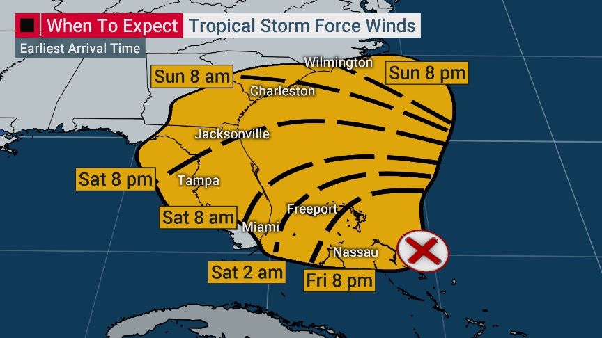
WIND: Tropical storm conditions are expected within the warning
area in the northwestern Bahamas later today.  Tropical storm
conditions are possible in the watch area on the Florida peninsula
by Saturday or Saturday night.

RAINFALL: The potential tropical cyclone is expected to produce
total rainfall accumulations through Sunday:

The Bahamas...2 to 4 inches, isolated maximum amounts 6 inches.
The U.S. Southeast Coast from central Florida into South
Carolina...2 to 4 inches.

STORM SURGE: This system is not expected to product significant
storm surge in the northwestern Bahamas.
